Great Junction Street
The Origins of Great Junction Street
At the end of the 18th century, the port of Leith was becoming very overcrowded and it was decided that docks were needed in adition to the existing wharves to accommodate the ever-growing number of ships coming into Leith. In 1799 an Act of Parliament was passed permitting the construction of a system of wet docks. Our main concern here is with the infrastructure that would enable goods to be taken to and from the new docks.
There is more about the construction of the docks in an article by Michael Nix in ‘Scottish Local History’, Issue No. 22, Summer 2001.
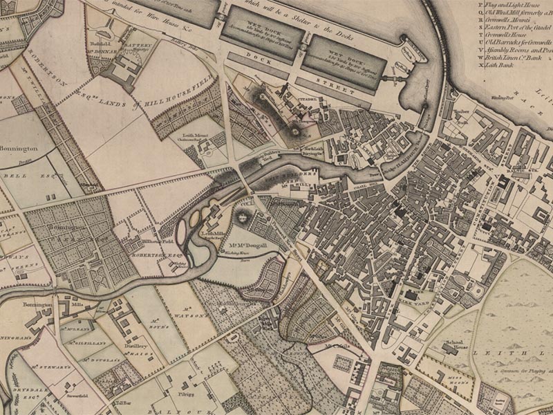
The plans for the new docks included a proposal for a new road that would connect the docks with Ferry Road (then usually called Queensferry Road), cross the Water of Leith on a new fixed high-level bridge and continue through open ground to the west of the old town of Leith to join and form a junction with Leith Walk. On Map 1 (above) this road is shown as ‘Proposed New Street’. On Ainslie’s Plan this proposed new street can be seen cutting through open ground – it looks very much like a modern by-pass.
This new road and bridge were needed because of the unsatisfactory nature of the existing infrastructure. When the dock project started the only bridge across the Water of Leith was a drawbridge at Tolbooth Wynd, later called the ‘Upper Drawbridge’. This was hardly a satisfactory route for traffic to and from the docks. It led into the narrow and congested streets of old Leith and as it was a draw bridge, delays could be expected when the bridge was raised to permit access for shipping.
A second drawbridge, the ‘Lower Drawbridge’, was constructed in 1808. This led from Bernard Street to Commercial Street and gave access to the new Custom House that was built in 1811-13. This permitted traffic from the docks to take the rather wider route through Bernard Street and Constitution Street to Leith Walk. The possibility of delay that was inherent in a drawbridge was still there. It was, however, to be many years before the new route was fully available.
Why was it called Great Junction Street? Nowadays if a new street is built the local Council decides what name should be given to it. This was not always so in the past. Sometimes streets were named by landowners or developers. Sometimes street names arose from popular usage – what local people called the street concerned. Such names might arise from the function of the street, the name of a building on it or perhaps the name of some local character.
The ‘Junction’ part of the street name is obviously functional as it would, when completed, provide a junction between the new docks, Ferry Road and Leith Walk. Popular usage up to the present day suggests the name ‘Junction Road’ – a name that was formally preserved for some years in the name of St Thomas-Junction Road Church and that was reflected in the name of the railway station that once stood next to Junction Bridge. Possibly in the early days local people would refer to ‘the junction road’ in the same way as in some towns nowadays people refer to ‘the bypass’ whatever its formal name might be.
On a map published in 1822 (Thomson’s Plan of Leith and its Environs) the name ‘Great Junction Street’ is used on the stretch of road now known as North Junction Street – the road to the South of Junction Bridge was still ‘proposed new road’. Perhaps the ‘Great’ was added in imitation of the use of that word in some of the Edinburgh New Town names, for example Great King Street. The northern section of the street became known as Great Junction Street North, then Great North Junction Street and finally North Junction Street. It is not known who actually decided on the basic name and these subsequent changes.
This information is from the book ‘Place Names of Edinburgh’; by Stuart Harris, published by Steve Savage Publishers Ltd in 2002. Its ISBN is 1-904246-06-0.
Great Junction Street – the Early Years

Map 2 above shows that the ‘proposed new street’ shown on Ainslie’s 1804 plan still had that status 18 years later as regards the stretch between Bonnington Road (shown here as Spence Place) even though Junction Bridge had been completed in 1818. The bridge was initially a "bridge to nowhere" - it could be crossed on foot or on horseback but there was no through route for heavy vehicles making their way to Leith Walk.
The problem was that building the road was the responsibility of the landowners though whose lands it would pass and they would only do so if it was to their financial advantage. They would, for instance, be able to benefit if they could feu lands for development on their road frontages.
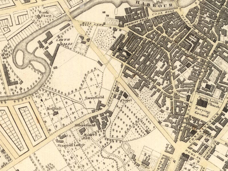
The extract from Thomson in Map 2 shows that shortly after leaving Junction Bridge the route of the new road was blocked by buildings which would have to be demolished. Map 3 shows another map published in 1822 – Lothian’s plan of Leith and its Vicinity. It shows a problem at the Leith Walk end, where a line of buildings that took Leith Walk to a point where it met the Kirkgate obstructed the ‘proposed new street’. These buildings would have to be demolished before any new road could connect with Leith Walk. As Thomson does not show this obstacle, this suggests that the problem had been solved by the time he did his survey. Although both maps were published in 1822, differences in detail suggest Lothian’s was the earlier survey.
Landmark Buildings
The first major development was the building of a church for the denomination then known as the Relief Church (later the United Presbyterian Church, the United Free Church, the Church of Scotland and now Mohiuddin Jamia Masjid & Education Centre). This building was known for much of its recent history as St Thomas Junction Road Church of Scotland. It was completed in 1825.
Another landmark building is Dr Bell’s School, completed in 1839. Dr Bell was a Church of England clergyman who had served as a chaplain to the East India Company and who became the superintendent of an orphanage for the orphans of British soldiers in India. While there he devised a system of education called ‘the Madras System’. This involved the teacher in teaching a group of the brightest pupils who then had to teach the same material to their fellow pupils.
Great Junction Street in the 1830s and 1840s
We can catch a glimpse of Great Junction Street in the 1830s and 1840s by looking at the entries in the Directories for that period. The main source is the Edinburgh and Leith Post Office Directory which was published annually. For some years an alternative directory, Gray’s Annual Directory, is also available. These directories can be consulted in the Edinburgh Room at Edinburgh Central Library.
Gray’s Annual Directory for 1832/33 contains only 12 entries for Great Junction Street, one of which is for the ‘Relief Chapel’, i.e. Junction Road Church. There is a small group of street numbers in the range 1-5 and it is thought that these represent properties at the Leith Walk end. The occupiers of these properties appear to be retailers – a druggist, a merchant, an ironmonger and a cowfeeder (dairyman). These properties were close to the existing retail centre of Leith in the Kirkgate.
The remainder of Great Junction street was occupied by trades that required a lot of space. There was a builder, a couple of wood merchants, a gardener and a ‘patent flooring machine and pill box manufactory’. It is difficult to give a precise location for these businesses but clearly there was plenty of space. At the Junction Bridge end of the street, Leith Saw Mills was located at the western side of the road.
The engineer of Leith Saw Mills, Timothy Burstall, also lived in Great Junction Street – probably somewhere near the Saw Mills. As well as being the engineer to Leith Saw Mills, Timothy Burstall has a claim to fame as a pioneer of steam locomotion. He built a steam carriage which he tried out on Queensferry (now Ferry) Road. He was also one of the (unsuccessful) competitors in the Rainhill Trials held on the Liverpool and Manchester Railway in 1829. The object of the trials was to find the most appropriate type of locomotive for use on the new railway. Despite his lack of success, Burstall nevertheless deserves to be remembered as a pioneer of steam traction.
If we move forward to the 1848/49 edition of the Edinburgh & Leith Post Office Directory, there were still only 13 entries for Great Junction Street – actually it was called ‘Junction Street South’ in that edition. This was twenty years after the opening of Junction Bridge and still there were plenty of open spaces.
The entries included a cluster of retailers at numbers 1-5 and the teacher and janitor of Dr Bell’s School which had been opened in 1839. Besides a number of wood merchants etc, there were two new names. One was John Crabbie and Sons – whose premises are still there in Great Junction Street, although converted into flats in the 1990s. The other was Hawthorn and Co Engineers. This Newcastle based firm established their Leith works in 1846 on a site on the eastern side of Great Junction Street immediately to the south of Junction Bridge.
Another development in the 1840s was the coming of the railway. The Edinburgh, Leith and Granton Railway (later the North British Railway) opened its Leith branch in 1846. This involved the formation of an additional arch to Junction Bridge on the north side of the Water of Leith to span the new railway tracks. From the walkway below Junction Bridge you can see the different types of masonry used for the original bridge and for the new arch that was necessary to cross the railway. There was as yet no station on this part of the line. Junction Road Station was opened in 1869.
Great Junction Street in the 1850s
For our study of Great Junction Street in the 1850s we have the advantage of having access to the large scale Ordnance Survey Town Plan which was surveyed in 1852.
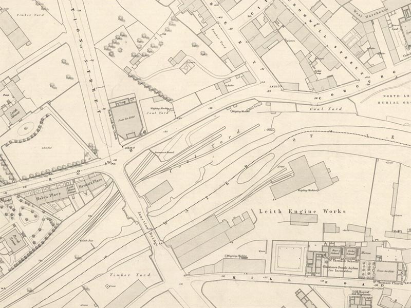
Starting at Ferry Road, Map 4 ahows Great Junction Street first crosses the extended bridge over the railway line and then over the Water of Leith. The railway line divides by the bridge with the main line entering a tunnel under Coburg Street and a siding branching off into a coal yard. After crossing over the bridge we find ‘Leith Engine Works’ lying between the Water of Leith and Mill Lane. This can be identified as Hawthorn’s works using information from the Edinburgh & Leith Post Office Directory for 1851/52.
Mill Lane is shown as crossing Great Junction Street – the western part became Ballantyne Road in 1896. Between the western part of Mill Lane and the Water of Leith there is an area labelled ‘Timber Yard’. This is the same area as was occupied by Leith Saw Mills earlier. Since the Directory shows several wood merchants in Great Junction Street, we cannot be sure which of them occupied this site.
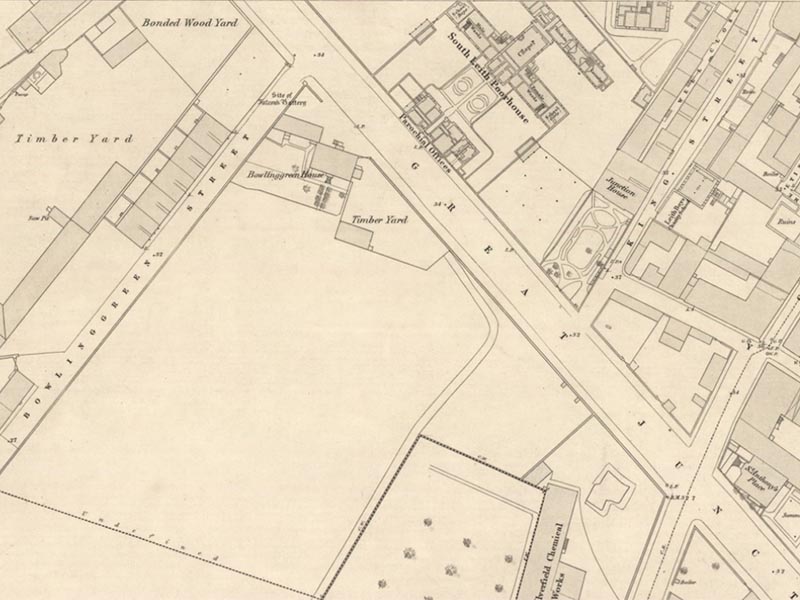
Continuing along Great Junction Street south of Mill Lane, Map 5 shows the first building encountered on the east side would have been the new South Leith Poorhouse (or Poor’s House) and Parochial Offices. These had been opened in 1850 and more information about them is contained in Appendix 1. Opposite was another timber yard and again we cannot say which of the several wood merchants occupied it.
Continuing along the east side of Great Junction Street, the plan shows an open space followed by what looks like an elaborate garden attached to a house called ‘Junction House’ in King Street. This was the home of James Pope, a wine and spirit merchant whose business was at 23 Charlotte Street, Leith. It is not known when this house was built. This may earlier have seemed to be a desirable ‘out of town’ site but by 1852 this seems less so as it was sandwiched between the Charity School and the Poorhouse!
Apart from these features, Map 6 shows us a lot of open space – confirming the impression gained from the Directory that much of Great Junction Street remained comparatively undeveloped at this stage.
The next stretch of Great Junction Street is shown in figure 8. Here we can see the intersection of Bonnington Road (here labelled Spence’s Place, a name which it carried from 1812 to 1890), Great Junction Street and Cables Wynd. Just off Bonnington Road can be seen the Silverfield chemical works and Swanfield Mills. Beside the intersection of Great Junction Street and Cables Wynd is St Anthony’s Place.
On the west side of Great Junction Street we can see two of our landmark buildings – Junction Road Church (labelled United Presbyterian Church) which has seats for 1400 people and Dr Bell’s School. There is a space between them. At the side of Dr Bell’s School can be seen the line of what was to become Junction Place but which was for many years regarded as part of Great Junction Street. It is difficult to identify the occupants of this side street but it is thought that they may have included Alex. Todd, a ‘split lath merchant’.
Moving along Great Junction Street we come across another church labelled as ‘Free Church’ and having seating for 760 people. This seems to be on the site now occupied by Leith Methodist Church. The Free Church of Scotland had been formed in 1843 when many people left the Church of Scotland. This church in Great Junction Street was not, however, the church formed by the people who left South Leith parish Church in 1843. It was rather formed by a group of people who broke away from an earlier Secession church that was situated in the Kirkgate right next to South Leith Parish Church. They eventually joined a denomination called the Old Secession Church and that church joined the Free Church in 1850. The church in Great Junction Street was known as Trinity Free Church and was an old wool store. Eventually it was found that the church was structurally unsound and it was demolished. They built a new church in Hope Street (now Casselbank Street) but it blew down in a storm a few months later. It was rebuilt but the financial strain of building two churches within a short time proved to be too much and the church was dissolved. The site in Casselbank was later re-used by the Elder Memorial Free Church.
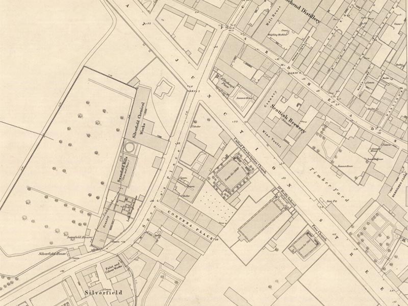
Opposite Junction Road Church is a building labelled ‘wine vaults’ which can be identified as Crabbies premises and opposite Dr Bell’s School is a timber yard. Next to it is what appears to be a formal garden completed with trees. There is still plenty of empty space in this part of Great Junction Street.
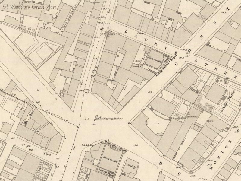
Map 7 shows the final segment of Great Junction Street as shown on the 1852 Town Plan and takes us its intersection with Leith Walk. Here, on the west side, the street is built up to the line of the pavement for a short distance. This is almost certainly the part occupied by retail trade.
Great Junction Street in the 1860s and 1870s
In the 1860s and 1870s we get a lot more information in the shape of newspapers and the advertisements that they carried. There was also another large scale Ordnance Survey in 1878 and comparison with the earlier edition enables us to track changes made in that period.
Street numbers were allocated to premises in Great Junction Street in this period. There had always been a few street numbers but circa 1860 an attempt was made to issue numbers for the whole street. This was done by issuing consecutive numbers up one side of the street and back down the other side – not the system that we are used to nowadays with odd numbers on one side and even numbers on the other. This system did not readily permit the numbering of any new buildings. The street was renumbered a few years later but still the consecutive numbering system was used. The final renumbering took place in 1875. This time the odds and evens system was used and gaps were left for new developments. Those numbers are still used today.
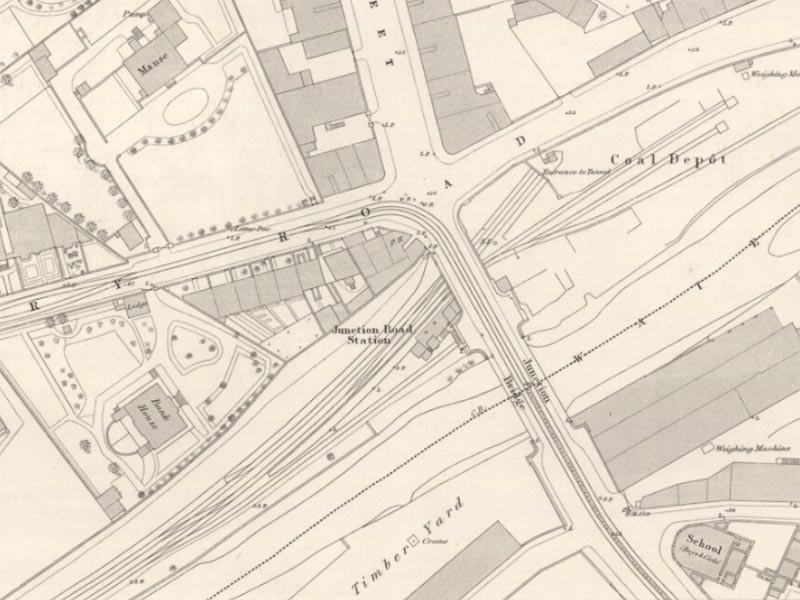
On Map 8 we can see the Junction Bridge area as it was in 1876. It is not substantially different to what we saw on the 1852 survey except that Junction Road railway station is now on the north-west side of the bridge. The railway had run along this line since 1846 but the station was not built until 1869. Originally trains running along this line would have joined the line from Granton at Warriston and then continued to Scotland Street Station. From Scotland Street the train went via a cable hauled incline in a tunnel to a station on approximately the site later occupied by the Waverley Market. You can still see the entrance to the tunnel at Platform 20 in Waverley Station. By the 1860s, this arrangement was unacceptable on a mainline of a major railway company and in 1868 the North British Railway opened a new line from Bonnington to Abbeyhill so that trains could be hauled by locomotives from Waverley to either Granton or Leith. Later some new stations were opened one of which was Junction Road Station.
Moving further along the street we can see some changes in this area too. The South Leith Poorhouse is still there unchanged but Junction House which once stood on the corner of Great Junction Street and King Street has gone. Junction house was offered for sale by public roup (auction) in 1871 and it is clear that it was a substantial and well appointed house. It was, however, in the wrong place. The sort of people who would want this type of house would almost certainly not want to live on a site sandwiched between the Poorhouse and the Smallpox Hospital and within earshot of Hawthorn's works. Its fate was to become the coal yard of Mr James Sword.
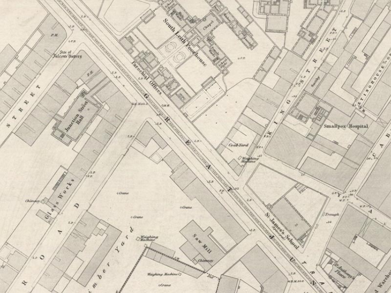
There are other changes apparent from this plan. Opposite the Poorhouse there is longer a timber yard. Instead there are buildings right up to the pavement and the Edinburgh & Leith Post Office Directory shows that these were occupied at ground level by shops and that there was residential property above. Opposite the Poorhouse is Junction Street Hall. This is located behind the buildings that fronted onto Bangor Road, Great Junction Street and Bowling Green Street. It was accessed via passages through the buildings on Great Junction Street and Bowling Green Street. For many years this was an important venue for social events in Leith.
Moving further down the street, St James’ Episcopal School occupies a site at the corner of Great Junction Street and Cables Wynd. This was the school run by St James’ Episcopal Church in Constitution Street. Figure 12 below shows St James School and Hall and the different architectural styles suggest that the school and hall may have been built at different times. The picture appears to depict a building extending to the line of King Street whereas the 1876 Town Plan shows a vacant site between the school and King Street. It is assumed, therefore that the right-hand side of building is the school and the left-hand side the hall.
For a short time in the late 1860s and early 1870s, there was another school nearby – St Anthony House Academy. Clearly this establishment had pretensions. It was for the education of ‘young ladies and gentlemen’ – not mere girls and boys! It is difficult to locate the precise site of this school but the street number used suggests that it was between St James’ Episcopal School and Crabbie’s Warehouse. Presumably it did not survive very long as it cannot be traced on the 1876 Town Plan – unless it is the long narrow building shown right at the junction with Cables Wynd.

Map 10 shows the area around Dr Bell's School. Our ‘landmark buildings’ are still there – Junction Road Church (with seats for 1400) and Dr Bell's School. The site between them is occupied by a Saw Mill belonging to John Dickson, a builder. Moving on we can see the entry that later became Junction Place. Then comes the building labelled ‘Methodist Chapel (Wesleyan)’.It had seats for 700 people. This is not the building currently occupied by Leith Methodist Church – it dates from the 1930s – but it is on the same site. It was something of a surprise to find the Methodist Chapel on this site in 1876 because one published account had suggested that the Methodists had only moved to this site when an early site in Duke Street was required for the new Central Station in the first years of the 20th century. The 1852 Town Plan does indeed show a Wesleyan Chapel at the corner of Leith Walk and Duke Street but in 1876 this building was occupied by the Star Music Hall.
Great Junction Street in the 1880s and 1890s
By the early 1880s much of Great Junction Street was already built up so that from this point we will be looking at the infilling of the few remaining vacant spaces and the redevelopment of existing built-up sites.
At the Junction Bridge end, Hawthorns continued in business. Ship repairs being executed alongside the works reminds us that the Water of Leith was navigable as far as Junction Bridge. The sort of work done must have made them very noisy neighbours for the South Leith Poorhouse and for Leith Hospital!
Moving further down Great Junction Street we come across a site, opposite St James' Episcopal School and the entrance to King Street, intriguingly name ‘Royal Circus’.
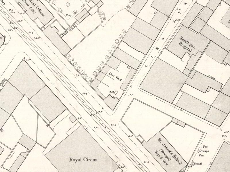
On 3rd January 1888, the Scotsman carried a report of the New Year festivities that year. It reported that ‘the new circus in Junction Street received a very large share of the public patronage. In this place of amusement there were five performances given, each of which was well attended, especially the last one, when the building was crowded in every place, many having to be turned away’. This was despite the streets not being ‘in the most pleasant walking condition in consequence of the melting snow’.
Returning to the vicinity of Dr Bell’s School there are some changes to be noted as compared with the earlier views from this area. The School itself was physically unchanged but had passed into the control of Leith School Board – the monitorial system was abandoned and it became a conventional school where the children were taught by teachers.
The Wesleyan Chapel is still there but now claims to have seats for 500 rather than 700 as in 1876. Behind it, however is a ‘Mission Hall’ with seats for a further 200 people. Mission Halls of this type were often built to allow people who felt that their clothes were unsuitable for attendance at the main church, to attend services. While we may find this a rather difficult notion to swallow, it was thought at the time that it showed consideration to poor people and spared them the embarrassment that they might have suffered from attending services with better-dressed people.
Behind the Chapel and the Mission Hall is a building labelled ‘Fire Engine Station’. This was the headquarters of the Leith Fire Brigade from 1878 and the Firemaster, James Brown, lived on the premises.
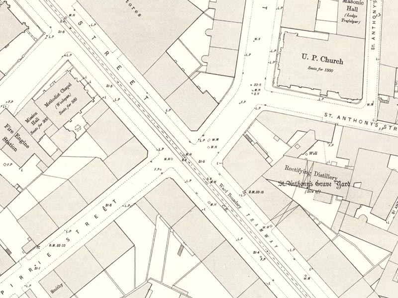
Two new streets appear on this section of the Town Plan, Map 12, Pirrie Street and Henderson Street. The latter was part of a major ‘improvement scheme’ under which a new road was constructed to the Shore and large numbers of insanitary slums (perhaps we would regard them as interesting mediaeval buildings) were swept away from the heart of old Leith.
About the project
There were various reasons for choosing Great Junction Street as the subject for a historical research project.
- Firstly, its history does not go back much beyond the start of the 19th century and our first attempts at historical research would be unlikely to require special skills in reading documents written in obscure hands or old styles.
- Secondly, while it is mentioned in many of the books that have been written about the history of Leith no-one seems to have done any detailed work focussing on Great Junction Street.
- Thirdly, it is an interesting street with a variety of residential, commercial, industrial, church and public service occupation – just how varied and interesting soon became apparent when we got involved in the research process.
We started this research using the Edinburgh and Leith Post Office Directory. There is an uninterrupted run of this directory, which was published annually from 1805 to 1974/75, available in the Edinburgh Room – the local studies section of the Edinburgh Central Library. We were able to extract from the street directory at roughly 10-year intervals particulars of the commercial and industrial occupation – and some residential occupation - and by comparing the results were able to track changes and developments over the years. We quickly ran into problems with street numbers - in the early days there were very few numbers but there were three different renumbering schemes in the period from the 1850s to the 1870s. The street numbers have remained the same since about 1875 and this has proved helpful in tracking changes and continuity in the subsequent period.
The large scale Ordnance Survey Town Plans (surveyed at approximately 20 year intervals from the 1850s to the 1890s) also proved extremely useful for tracking changes to Great Junction Street in the 19th century. These can be consulted on the National Library of Scotland maps website and show even such details as the location of lamp posts.
One aspect that needs to be remembered is that for the period from 1833 to 1920, Leith was an independent burgh – separate from Edinburgh. This meant that it had its own Town Council, School Board and various other administrative bodies during that period.